That's precisely the problem drone telemetry solves. It creates a continuous, real-time data connection between your UAV and the ground, giving operators the situational awareness to make informed decisions before a situation becomes an emergency.
This guide covers everything from what drone telemetry is and which flight parameters it captures, to how telemetry systems work mechanically, where they're used, and what separates consumer-grade setups from professional aerospace-grade systems.
Key Takeaways
- Drone telemetry transmits real-time flight data (GPS, altitude, battery, attitude, signal strength) from UAV to operator
- Key parameters include position, vertical speed, roll/pitch/yaw, power levels, and RSSI
- IRIG 106 governs professional and flight test applications; MAVLink is the open-source standard for civilian consumer drones
- RF interference, data security gaps, and regulatory frequency constraints are the most common operational challenges
- Professional systems differ significantly from consumer hardware in range, data throughput, encryption, and standards compliance
What Is Drone Telemetry?
Drone telemetry is the automated, real-time process of collecting flight data from onboard sensors and transmitting it wirelessly to a ground operator or control station. Unlike basic RC control signals — which only send commands to the drone — telemetry sends flight status back to the operator.
This creates a bidirectional data stream. Control commands travel from the ground station to the drone. Flight status — position, speed, battery level, attitude, signal quality — travels the other direction. That two-way flow is the foundation of safe UAV operations, particularly for anything beyond basic line-of-sight flying.
Telemetry Across Different Use Cases
The scope of telemetry varies considerably depending on the application:
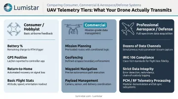
- Consumer/hobbyist drones: Built-in telemetry covering basic stats like battery percentage, GPS position, and return-to-home triggers
- Commercial drones: Richer data streams supporting mission planning, geofencing, automated waypoint navigation, and payload management
- Professional aerospace/defense: Standards-compliant systems capturing dozens of simultaneous data channels, with strict requirements for data integrity and interoperability
UAV (Unmanned Aerial Vehicle) is used interchangeably with "drone" throughout this guide. Telemetry principles apply across fixed-wing UAVs, rotary-wing multirotors, and hybrid VTOL platforms, though the specific parameters and data volumes differ.
The scale of this market reflects how broadly telemetry literacy matters. According to the FAA's current figures, there are 837,513 registered drones and 481,760 certificated remote pilots in the US alone — a commercial operator base that depends on reliable telemetry data for safe, legal operations.
Key UAV Flight Data Parameters Explained
GPS Position and Navigation Data
GPS telemetry delivers real-time latitude, longitude, and altitude data. For autonomous flight, this is foundational — geofencing, waypoint navigation, and return-to-home functions all depend on continuous, accurate position updates. Any gap in that data stream leaves the autopilot flying blind.
Altitude and Vertical Speed
Two separate sensors handle altitude:
- Barometric altitude: Derived from atmospheric pressure; highly responsive but subject to temperature and weather variation
- GPS altitude: Based on satellite geometry; less noisy over time but with lower vertical precision (PX4 documentation notes GPS receivers need vertical accuracy of 8 m or better for reliable calibration)
Flight controllers typically fuse both sources. Vertical speed (climb/descent rate) adds another layer — a sudden unexpected descent rate can indicate a problem long before it becomes visible to a ground observer.
Attitude Data — Roll, Pitch, and Yaw
Attitude describes the drone's orientation in three axes:
- Roll: Tilting left or right (like a plane banking into a turn)
- Pitch: Nose tilting up or down
- Yaw: Rotating left or right around a vertical axis
Each of these axes is monitored by the IMU (Inertial Measurement Unit) and gyroscopes, which feed continuous data to the autopilot. The flight controller uses that input to make hundreds of micro-corrections per second, keeping the aircraft stable.
Battery and Power Telemetry
Voltage, current draw, and remaining capacity are transmitted in real time. This is the most safety-critical telemetry stream for most operators. A sudden voltage drop doesn't just mean a shorter flight — it can trigger an emergency landing or cause loss of control if the battery voltage drops below motor-critical thresholds.
Airspeed, Ground Speed, and Heading
- Airspeed: Speed relative to the surrounding air (measured by a pitot tube on fixed-wing UAVs)
- Ground speed: Speed relative to the earth's surface (derived from GPS)
- Heading: The direction the drone's nose is pointing, from the magnetometer
These three together tell you where the drone is going, how fast it's moving over the ground, and whether wind is causing it to crab sideways.
RSSI (Received Signal Strength Indicator)
As defined in MAVLink's message specifications, RSSI is a numeric indicator of communication link quality between drone and ground station. A declining RSSI value is an early warning that the drone is approaching the edge of its operational range — or that something is interfering with the link. Most ground control software lets you set a minimum RSSI threshold alert so you can act before the link degrades past recovery.
How a Drone Telemetry System Works
Onboard Data Collection
The flight controller is the central hub. During flight, it continuously reads from multiple sensors simultaneously:
- GPS module (position and velocity)
- IMU and gyroscopes (attitude and acceleration)
- Barometer (altitude and vertical speed)
- Magnetometer (heading)
- ESCs — Electronic Speed Controllers (motor RPM and current)
- Battery management system (voltage and capacity)
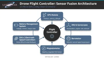
This sensor fusion process runs continuously; message intervals are configurable per parameter based on link bandwidth and mission priorities.
Telemetry Radio and Transmission
A dedicated telemetry radio module on the drone encodes sensor data into packets and transmits them to the ground. Two frequency bands are commonly used:
| Band | Typical Use | Trade-off |
|---|---|---|
| ~900 MHz (915 MHz in the US) | Longer-range MAVLink links | Lower bandwidth |
| 2.4 GHz | Shorter range, faster data rates | More RF congestion in urban areas |
Both bands fall under FCC 47 CFR 15.247 spread-spectrum rules. For 900 MHz frequency-hopping systems with at least 50 hopping channels, the permitted transmit power is 1 W; systems with 25–49 hopping channels are limited to 0.25 W.
Ground Control Station and Receiver
On the ground, the receiving antenna and radio module decode incoming data packets and feed them to ground control station (GCS) software. Common civilian options include Mission Planner for ArduPilot-based vehicles and QGroundControl for both PX4 and ArduPilot.
Operators work from live dashboards showing real-time position on maps, battery voltage graphs, altitude traces, and configurable alerts for out-of-range parameters.
Communication Protocols
MAVLink is the standard open-source telemetry protocol for civilian and commercial drones. It standardizes how data is packaged and transmitted, enabling different drone hardware and GCS software to communicate reliably. Both PX4 and ArduPilot use it as their primary communication layer.
One important security note: PX4's documentation states that MAVLink messages are unauthenticated by default. Production deployments should enable message signing, which provides authentication and integrity — though messages remain plaintext without additional encryption.
For professional aerospace applications, IRIG 106 sets more rigorous requirements, governing how flight test data is formatted, transmitted, and archived to ensure interoperability across test ranges and programs.
Data Logging and Post-Flight Analysis
Those protocol standards shape not just transmission but also how data gets stored. Telemetry is logged to onboard storage (SD card or flash memory) and/or the ground station — creating a record that outlasts any single flight.
Post-flight log review lets operators:
- Identify anomalies that weren't visible in real time
- Verify that autonomous missions executed as planned
- Schedule maintenance before minor issues become failures
Real-World Applications of UAV Telemetry Data
Agriculture and Mapping
In precision agriculture, GPS and altitude accuracy directly determine the quality of the data collected. Telemetry keeps drones on precise, repeatable flight paths — a requirement for reliable results across several deliverables:
- Orthomosaic maps with accurate geometric registration
- NDVI (Normalized Difference Vegetation Index) crop health imagery
- Consistent ground sample distance across survey areas
- Repeatable flight paths for season-over-season comparison
Even small altitude deviations skew the ground sample distance and compromise imagery accuracy.
Infrastructure Inspection and Search & Rescue
Real-time telemetry lets operators position drones safely near bridges, communication towers, or disaster scenes without being able to see the aircraft directly. FHWA bridge inspection research explicitly documents UAV command-and-control setups with downlinks providing telemetry, video, and real-time data to pilots — noting that large inspections can generate over 50 GB of imagery and related data. Battery and signal telemetry are especially critical in these missions, which often push range and endurance limits.

Aerospace and Defense Flight Testing
Flight test telemetry operates at a different scale from commercial UAV work. NASA's AirSTAR UAV research platform used over 70 downlink data channels plus video and 30 uplink control channels — a data density that demands purpose-built systems and formal standards compliance. At ranges like Edwards Air Force Base, ground telemetry stations receive data from aircraft under test and relay it to mission control for real-time performance monitoring. At this level, IRIG 106 compliance is a hard requirement, not a design option.
Common Challenges in Drone Telemetry
Signal Interference and Range Limitations
Buildings, terrain, dense vegetation, and competing RF traffic in the 2.4 GHz band can all degrade or break the telemetry link. Frequency Hopping Spread Spectrum (FHSS) — used in SiK-style radios — helps by rapidly cycling through frequencies rather than locking onto one channel. Directional antennas can extend effective range, though they require the operator to continuously track the aircraft.
Data Security Risks
Beyond signal stability, the data flowing through a telemetry link is itself a target. Telemetry streams expose sensitive operational information, including:
- GPS coordinates and real-time position
- Active flight plans and waypoints
- Payload status and command inputs
By default, MAVLink doesn't encrypt this traffic. GPS spoofing is a documented threat — peer-reviewed research confirms that civil GPS signals can be manipulated to misdirect or hijack UAVs. Defense and commercial operators should treat encrypted data links and authenticated command protocols as baseline requirements, not optional add-ons.
Regulatory Constraints on Frequencies and Power
Security considerations aside, operators also face hard regulatory boundaries. The FCC governs which frequency bands UAV operators can use in the US and at what transmit power levels. Telemetry hardware must comply with Part 15 spread-spectrum rules — operating outside these limits creates legal exposure and risks interference with aviation and emergency communications systems.
From Hobbyist to Professional: Scaling Your UAV Telemetry
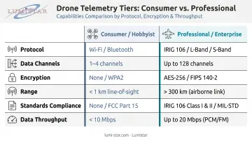
Consumer-grade telemetry — built into off-the-shelf drones — handles basic position, battery, and signal status adequately for recreational flying and light commercial work. The jump to professional-grade systems is substantial:
| Capability | Consumer/Hobbyist | Professional/Enterprise |
|---|---|---|
| Protocol | MAVLink (default config) | MAVLink (hardened) or IRIG 106 |
| Data channels | Single-digit to ~20 | Dozens to 70+ |
| Encryption | Optional/manual | Integrated, required |
| Range | 300 m to a few km | Mission-dependent, extended |
| Standards compliance | FAA Part 107 | IRIG 106, RCC range requirements |
| Data throughput | Low-moderate | Up to 60 Mbps |
The scenarios that signal a need for professional-grade telemetry include:
- Flight test programs validating new aircraft designs
- Defense or military UAV operations
- Federal test range operations
- BVLOS (Beyond Visual Line of Sight) missions requiring FAA authorization
- Any program where data integrity is mission-critical rather than a convenience
Those programs require purpose-built hardware — and that's where manufacturers like Lumistar come in. Based in San Marcos, California, Lumistar specializes in exactly this space. Founded in 2000 by experienced telemetry engineers, Lumistar produces modular, IRIG 106-compliant systems used at federal test ranges and commercial flight test facilities. Their product line covers the complete signal chain — RF reception, demodulation, bit synchronization, PCM processing, and data display/archiving.
The LS-28-DRSM series is a concrete example: a multi-band receiver/combiner/processing unit under 1 kg, supporting data rates up to 60 Mbps across 200 MHz to 7 GHz, with integrated encryption/decryption for secure operations.
Lumistar's engineering teams have supported programs including Virgin Orbit's LauncherOne missions and the Kansas Supersonic Transportation Corridor flight test infrastructure. All hardware is designed and manufactured in the USA, and the company offers unlimited post-delivery technical support, especially valuable during active flight test campaigns.
Frequently Asked Questions
What is UAV telemetry?
UAV telemetry is the real-time collection and wireless transmission of flight data from an unmanned aerial vehicle to a ground operator or control station. Transmitted parameters include position, speed, altitude, battery status, and system health. It enables safe, informed flight operations by giving operators continuous visibility into aircraft state.
How do you use UAV telemetry?
Operators monitor live data dashboards on a ground control station during flight to track position, power levels, and signal quality. After the flight, operators review logged telemetry data to analyze mission performance, identify anomalies, and support maintenance decisions.
What data does drone telemetry collect?
Core parameters include:
- GPS coordinates and altitude (barometric and GPS-derived)
- Airspeed, ground speed, and attitude (roll, pitch, yaw)
- Battery voltage, remaining capacity, motor/ESC status, and RSSI
Professional systems can capture dozens of additional sensor channels simultaneously.
What does UAV stand for?
UAV stands for Unmanned Aerial Vehicle — used interchangeably with "drone." It refers to any aircraft operating without an onboard human pilot, including both remotely piloted and fully autonomous systems.
What are the types of UAVs?
The three main categories are fixed-wing UAVs (efficient for long-range cruise), rotary-wing/multirotor UAVs (capable of hovering and precise maneuvering), and VTOL hybrids (combining vertical takeoff with efficient forward flight). Telemetry requirements differ across these types based on flight profile and mission complexity.
What is IRIG 106 and why does it matter for drone telemetry?
IRIG 106 is a set of telemetry standards developed by the Range Commanders Council governing how flight test data is formatted, transmitted, and recorded. It's the required standard for aeronautical, defense, and federal test range applications. Compliance ensures data accuracy and interoperability across different systems and facilities.